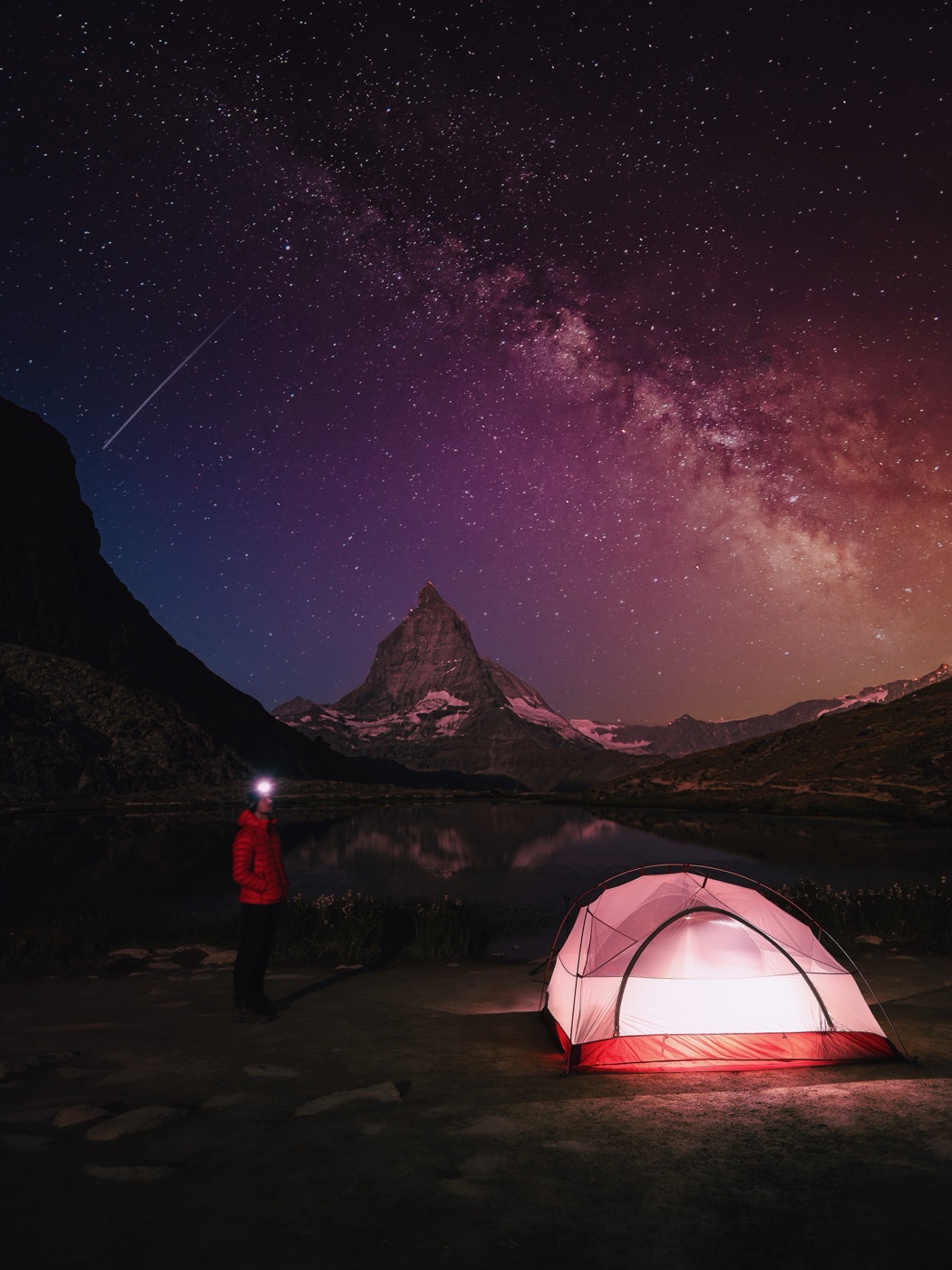
Riffelsee, how to catch the Matterhorn reflection at sunrise
The Matterhorn, doubled. At first light the tip turns red before the rest of the mountain catches up. Here is how to be standing at the lake when it happens.
Swiss Gems · 141 spots in Switzerland
Access, best light and a wild camping status per spot. One-off CHF 27, free updates.
Getting there
Take the Gornergrat Bahn from Zermatt up to Rotenboden2. From the station it is a short walk down to the lake, maybe ten minutes on an easy path. No real hiking, you can carry the tripod in one hand.
The catch is the timetable. In summer the first train of the day reaches Rotenboden after sunrise, and in the evening you are back down before the light gets good again. The train misses both golden hours. So if you want the red tip on a summer morning, the train alone will not get you there in time. Either you walk up in the dark, which is a long climb from the valley, or you sleep in a hut nearby, or you stay down and settle for harder light. More on the sleeping question below, because the obvious shortcut is not legal.
The photo
Shoot wide. 24mm or 35mm. That is what it takes to keep the peak and its reflection in the same frame, the mountain stands high above the lake.
The reflection only works if the wind stays down. A light breeze is enough to break the mirror. Cross your fingers for a still morning and check the wind forecast the evening before.
Be in position before sunrise. The show is short: the red on the tip lasts maybe five minutes before full light floods in and kills the effect. Set up while it is still grey, fix your frame, then wait. Once the first colour hits the summit you will not have time to change lenses.
Swiss Gems · 141 spots in Switzerland
Access, best light and a wild camping status per spot. One-off CHF 27, free updates.
When to go
Late June to October. Earlier than that, at 2,757 metres1, the lake is usually still frozen or under snow, and there is nothing to reflect.
The honest downside is the crowd: 5 out of 5. This is the most-photographed spot at Gornergrat, and on an August weekend the shoreline fills up before sunrise. Weekdays beat weekends, and the shoulder weeks in late June and from mid September on are the quietest.
Can you stay the night?
No. Article 43 of Zermatt's municipal police regulation forbids camping on all public ground in the municipality, and it names the mountain lakes explicitly5. That covers Riffelsee, and it covers simply pitching a tent, not only sleeping in one. Regional police, wardens and rangers check the Rotenboden plateau regularly.
If they catch you, the standard fine is CHF 200 per tent7. The bigger risk is the bill behind it. The lake is not reachable by train at night, so a reported camp is often checked by helicopter, and Zermatt passes the full flight and operation cost on to whoever caused it, which can reach several thousand francs. The lake is also a nature reserve, so swimming and open fires are out as well1.
Riffelsee lies above the treeline, in the BLN protected landscape Dent Blanche-Matterhorn-Monte Rosa4. The SAC information sheet3 tolerates a single considerate bivouac night above the treeline, but only where no local rule says otherwise. Here the local rule is an outright ban across the whole municipality, so there is no higher or quieter spot near the lake that escapes it. The tolerance argument does not work at Riffelsee.
The complete legal breakdown, the fines and the legal dawn options, is in wild camping at Riffelsee.
Sleep at the Gornergrat
The Kulmhotel Gornergrat and the Riffelhaus 1853 are a short walk from the lake, so you can be at the shore for dawn or dusk without a tent. Note that the one campsite in Zermatt is closed for the summer 2026 season after a rockfall reassessment, and the municipality has said plainly that the closure does not make wildcamping tolerated6.
SAC huts
Several SAC huts sit around the Zermatt valley. Check the SAC hut directory for what is open and what fits your route.
Use the early and late trains
The Gornergrat Bahn runs special sunrise departures and a discounted afternoon ticket from 15:30, which close the gap between the normal timetable and the good light without breaking the rules on the ground2. Walking up from the valley is slow but lets you be at the shore before the first train.
If it is a real emergency
A genuine emergency bivouac, forced on you by injury, a sudden storm or rockfall, is allowed everywhere in the Alps and is never fined. Deliberately spending the night out to catch the sunrise is not an emergency, and the wardens treat it as planned, illegal camping7.
Riffelsee is in the Swiss Gems guide with its GPS pin, access notes and the wild camping verdict, next to 140 other spots I have mapped across Switzerland. If this kind of field note is useful to you, that is where they all live.
Swiss Gems · 141 spots in Switzerland
Access, best light and a wild camping status per spot. One-off CHF 27, free updates.
Frequently asked questions
When is the best time of day to photograph Riffelsee?
Can you camp at Riffelsee?
How much is the fine for wild camping at Riffelsee?
How do you get to Riffelsee?
Do you need to hike to reach Riffelsee?
Leon Helg
Swiss filmmaker and software developer. 26 years in Switzerland, spends his free time exploring the Swiss Alps and maps his favourite spots for Hikebeast. Posts as @leon.helg on Instagram and TikTok.
Sources
- Riffelsee, 2,757 m, above Zermatt near Rotenboden, canton of Valais. A designated nature reserve where camping, swimming and fires are prohibited. valais.ch. ↩
- Gornergrat Bahn, the railway from Zermatt to Gornergrat with the Rotenboden stop, including sunrise departures and a discounted afternoon ticket. gornergrat.ch. ↩
- Swiss Alpine Club, information sheet "Camping and bivouacking in the Alps": single bivouacs above the treeline are tolerated where no local rules say otherwise. sac-cas.ch. ↩
- Federal Office for the Environment (FOEN), geoportal with the BLN inventory and the layers "wildlife rest zones" and "federal hunting ban districts". map.geo.admin.ch. ↩
- Municipality of Zermatt, police regulation of 26 January 2022, Article 43: camping on public ground is prohibited, including at the mountain lakes. gemeinde.zermatt.ch. ↩
- Municipality of Zermatt, media release, the Zermatt campsite stays closed for the summer 2026 season after a rockfall reassessment; the closure does not make wildcamping tolerated. gemeinde.zermatt.ch. ↩
- Regional police practice in the Valais Alps: a standard CHF 200 fine per tent, helicopter operation costs passed on to offenders, and the legal exception for a genuine emergency bivouac. regionalpolizei-leuk-leukerbad.ch; 1815.ch. ↩